遙感輻射定標解決方案

概述與原理
解決方案
資料庫

在遙感領域,輻射定標對遙感工作的結果非常重要,遙感用的光譜成像系統需要定期標定。

輻射定標的原理

 反射率法:

在衛星過頂時同步測量地面目標反射率因子和大氣光學參量(如大氣光學厚度、大氣柱水汽含量等)然后利用大氣輻射傳輸模型計算出遙感器入瞳處輻射亮度值。

具有較高的精度。

 輻亮度法:

采用經過嚴格光譜與輻射標定的輻射計,通過航空平臺實現與衛星遙感器觀測幾何相似的同步測量,把機載輻射計測量的輻射度作為已知量,去標定飛行中遙感器的輻

射量,從而實現衛星的標定,最后輻射校正系數的誤差以輻射計的定標誤差為主。僅僅需要對飛行高度以上的大氣進行校正,回避了底層大氣的校正誤差,有利于提高精度。

輻照度法:

又稱改進的反射率法,利用地面測量的向下漫射與總輻射度值來確定衛星遙感器高度的表觀反射率,進而確定出遙感器入瞳處輻射亮度,。這種方法是使用解析近似方法來計算反射率,從而可大大縮減計算時間和計算復雜性。

輻射定標的分類

輻射定標按照定標位置不同可分為三類,分別是實驗室定標、機上和星上定標、場地定標

解決方案

光傲科技提供從實驗室到現場的各種定標用輻射度計、標準燈、靶標用于遙感領域的光譜輻射定標,波長范圍覆蓋從紫外到中遠紅外波段。

  • 成像光譜儀的系統響應校正:采用OL 750 探測器光譜響應測試系統,對成像光譜系統對不同波段波長的靈敏度進行精確測定
  • 全系列積分球均勻光源提供最高精度、追溯 NIST 的光譜輻射亮度標準源,亮度可調,實現對成像光譜儀的系統定標,以及線性測試
  • 最全系列的光譜輻射照度標準燈,實現輻射照度法的輻射定標傳遞。
  • 提供各種遙感靶標,覆蓋從紫外可見波段到中遠紅外
  • 提供漫反射涂層,用于制作大面積野外遙感靶標
  • 便攜式光譜輻射度計,用于野外現場的輻射定標

特別推薦: OL 756 是全球唯一可以便攜使用的雙單色儀結構光譜輻射度計!

square2    square3
Example 36" square target using grey Avian D, nominal 30% reflectance

相關文章
資料庫內容


輻射度計及其在印度洪水中監測中的作用/Radiometers & Their Role in Measuring India’s Floods

Scientists around the world were able to gather a substantial amount of data during a period of deadly floods in India in late 2015. Through the use of satellites and their onboard radiometers, the space agency collected vast amounts of information regarding the storms that caused the flooding.

Two slow-moving tropical low-pressure systems caused extreme rainfall and resultant severe flooding in southeastern India. Death reports due to the flooding reached 70. But as the two systems dumped their significant payloads, NASA and its global partners recorded the data with multiple satellites.

Using a Dozen Satellites

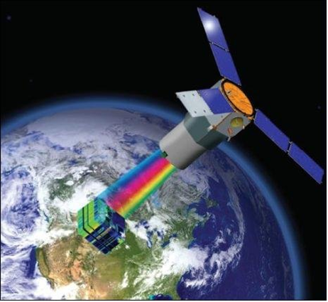
NASA used what’s called Integrated Multi-satellitE Retrievals for GPM (IMERG) to combine data from 12 satellites, including:

  • DMSP (Defense Mapping Satellite Program) satellites from the U.S. Department of Defense.
  • GCOM-W from the Japan Aerospace Exploration Agency (JAXA).
  • Megha-Tropiques from the Centre National D’etudies Spatiales (CNES) and Indian Space Research Organization (ISRO).
  • NOAA series from the National Oceanic and Atmospheric Administration (NOAA).
  • Suomi-NPP from NOAA-NASA.
  • MetOps from the European Organisation for the Exploitation of Meteorological Satellites (EUMETSAT).

All the radiometers on board each of the 12 satellites are inter-calibrated with information from the Global Precipitation Measurement (GPM) Core Observatory’s GPM Microwave Imager (GMI) and Dual-frequency Precipitation Radar (DPR). The GPM data is public and is accessible here.

Other Catastrophes

Earlier in 2015, IMERG data recorded an incident of extremely heavy bicoastal rainfall in Australia due to Cyclone Quang impacting the northwestern portion of Australia and another low-pressure system over the country’s southeastern regions. This event caused at least four deaths. In another instance, IMERG data captured historic rainfall levels in North and South Carolina, as well as the Bahamas, because of Hurricane Joaquin. The list goes on and on; you can see current IMERG readings here.

Perhaps soon, scientists will be able to do even more with data in terms of early warnings and other preventive measures. In the meantime, Gooch & Housego will continue to supply researchers and scientists with the very best photonic and radiometer technology. For more information, call Gooch & Housego today at 800-899-3171.


海洋表面溫度遙感監測與輻射定標

Did you realize that the sea surface temperature affects the Earth’s atmosphere? Not only can ocean temperatures contribute to the study of global warming, but they also can influence the formation of major storm events. Interestingly, a lot of what we know about how our oceans change comes from information gathered by satellites in our planet’s orbit. These satellites collect data on the amount of light the oceans emit and reflect to keep track of surface temperatures through ocean-color radiometry. And as you likely would expect, propercalibration services, including the detection equipment, is crucial.

The enormous amount of data involved is delivered from multiple satellite sensors over decades of time to the National Oceanic and Atmospheric Administration’s Marine Optical Buoy (MOBY), an automated radiometric system bobbing in the waters of the Pacific Ocean off Hawaii.

Of course, the instruments and data-collection system on MOBY itself has to be thoroughly characterized and calibrated, a complicated job for many reasons. Radiometric cross checks help provide robust traceability to the International System of Units (SI). What’s more, a three-month-long rotation of duplicate systems makes it possible to perform scheduled maintenance and repairs on MOBY.

While MOBY has long exceeded its expected lifespan, it continues to provide critical data and is expected to keep doing so for the foreseeable future. The fact that it still can provide accurate data is due to the rigorous calibration efforts employed by the buoy’s caretakers.

Calibration is of vital importance when dealing with your sensitive data. Therefore, it makes sense to ensure your technology is properly calibrated. With more than four decades of experience in photonics system design and manufacturing, Gooch & Housego has a global reputation as the expert in spectroradiometry for both instrumentation and calibration services, measurements from 200 nm to 30 µm in particular. They offer full product engineering, design, and manufacturing quick-turn capabilities, with specialized expertise in opto-mechanics and photonics systems. Gooch & Housego’s staff of expert engineers have many years of experience with demanding commercial product delivery, as well as custom-designed and OEM solutions. Call 光傲科技 today at 400-921-9858 to talk about your needs for calibration services.


美國 NIST 輻射定標:從地球到太空

NASA and the National Institute of Standards and Technology (NIST) are using multi-spectral imaging from orbiting satellites to provide detailed observations of the Earth, such as how our planet reacts to otherwise imperceptible changes in the Sun’s output. The data derived can help scientists create better climate models, which, in turn, can help us better manage our planetary resources.

The Earth’s Radiation Budget

DSCOVR (the Deep Space Climate Observer), launched in 2015 in a partnership between the National Oceanic and Atmospheric Administration (NOAA), NASA and the U.S. Air Force, features the NIST Advanced Radiometer. The NISTAR systematically measures whether the Earth keeps more radiation that it sends back into space.

Calibrating an EPIC Camera for Accuracy

NISTAR is certainly impressive, tracking the total amount of energy the sunlit side of Earth reflects and emits between the wavelengths of 0.2 and 100 micrometers, which goes from visible light to a significant portion of the infrared and ultraviolet bands. The NISTAR readings were used to help calibrate the Earth Polychromatic Imaging Camera (EPIC), and now NISTAR has topped the mission-mandated 1.5 percent absolute accuracy level.

Next up for NIST

Next up for NIST is the task of calibrating the Visible Infrared Imaging Radiometer Suite (VIIRS) sensor on a polar-orbiting weather satellite. Scientists hope that NIST will be successful in making it possible to measure three overlapping wavelength bands in order to distinguish the Earth’s radiant power from reflected solar energy. Once this is accomplished, climatologists will have much better data to study and from which to draw climate-impact conclusions. The first launch in the Joint Polar Satellite System (JPSS), weather satellite series is slated for November 2016.

Spectral Imaging Innovations

The use of spectral imaging to improve image analysis, and specifically to allow discrimination between visually identical objects, is steadily growing. Gooch & Housego is proud to contribute to valuable research being done through multi-spectral and hyperspectral imaging, and can partner with you in your spectral imaging endeavors.


  發送給朋友| 打印友好
滬ICP備13003137號-1